


![Trail Other activity Val de Bagnes - Col des Avouillons [loop/boucle/Rundwand.] - Photo](https://media.geolcdn.com/t/1900/400/ext.pjpeg?maxdim=2&url=https%3A%2F%2Fstatic1.geolcdn.com%2Fsiteimages%2Fupload%2Ffiles%2F1545311037marcheuse_200dpi.jpg)
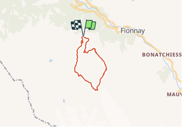
Col des Avouillons [loop/boucle/Rundwand.]

pnoth
User

Length
9 km

Max alt
2649 m

Uphill gradient
733 m
Km-Effort
18.8 km

Min alt
2012 m

Downhill gradient
736 m
Boucle
Yes
Creation date :
2014-12-11 00:00:00.0
Updated on :
2014-12-11 00:00:00.0
--
Difficulty : Unknown

FREE GPS app for hiking
 SityTrail
IGN / Geographical institutes
SityTrail Plus
The world is yours!
About
Trail Other activity of 9 km to be discovered at Valais/Wallis, Entremont, Val de Bagnes. This trail is proposed by pnoth.
Description
English: http://www.noth.ch/h0126_e.html
Français: http://www.noth.ch/h0126_f.html
Deutsch: http://www.noth.ch/h0126_d.html
Positioning
Country:
Switzerland
Region :
Valais/Wallis
Department/Province :
Entremont
Municipality :
Val de Bagnes
Location:
Unknown
Start:(Dec)
Start:(UTM)
366460 ; 5098851 (32T) N.
Comments